


Highways and Bridges Commemorated on U. S. Postage Stamps A Philatelic Transportation Venture |
|---|
|
George Austin Hay
Undated
The transporting of letters and postcards by mail has been going on for years. Stamps required for this activity have pictured every conceivable topic imaginable-overing the unique heritage of America. Narrowing the subject to highways and bridges points up a pictorial view of history.
In a postage stamp there is a particular kind of art-a small-size design that portrays a large side of national history. That stamp not only is used in moving the mail, but evokes a part of our unusual past.
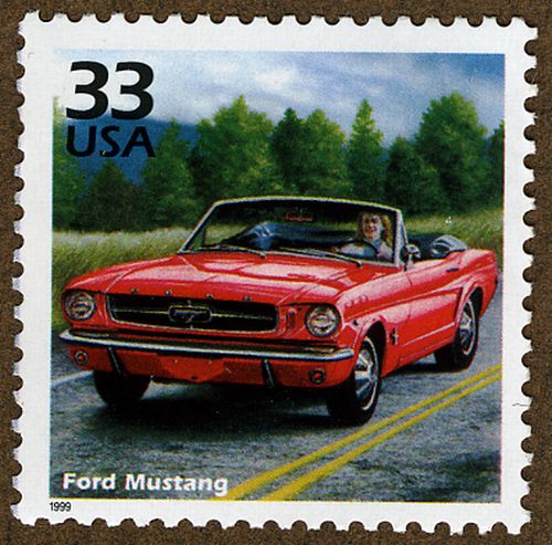 |
On The Highway Issued in 1999 This mint stamp clearly shows a highway with the double yellow line dividing opposite lanes of travel-a safety device familiar to every motorist nationwide. Such a marking is needed expressly when driving at night. |
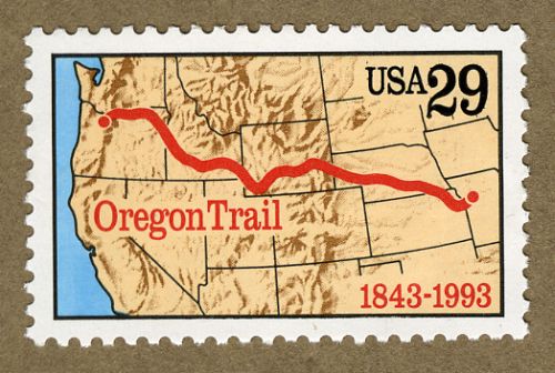 |
The Oregon Trail Issued in 1993 In 1843, the Oregon Trail was one of the early routes of travel for pioneer settlers heading west, which began at Independence, Missouri. The push westward was made by the French, Dutch, Spanish, Russian, and Americans. Many felt it was the best route to the coast. Fur traders, missionaries, and farmers drove wagons over a well-beaten trail. Those seeking California gold crowded the stream of travel near the Great Salt Lake. One of the important events was the Statehood of Oregon, in 1856. The majority of travel consisted of overland stage coaches and the Pony Express. Riders galloped along around the year 1860. Then came the railroad in 1869, and since then the Oregon Trail became United States Route 30. |
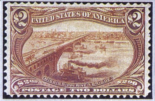 |
The Mississippi River Bridge AKA The Eads Bridge Issued in 1898 The Eads Bridge over the Mississippi River at St. Louis was constructed from 1867 to its opening in 1874. The structure was built by Captain James Buchanan Eads, and is considered the first bridge made of steel. The U.S. Postal Service preferred to attach the sobriquet "Mississippi River Bridge" rather than employ the proper, personal, private name "Eads." The span is double deck, with the upper level carrying a highway with sidewalks. On the lower deck, two lines of railroad tracks fill the space. This marks the first time steel is used in truss-bridge construction. A franchise was obtained from Congress specifying that a clear span of 500 feet must be provided. A report, published by Captain Eads in 1868, was a convincing presentation in non-technical language, on the "action of trusses and arches, also the logic of the foundation design." Progress, along with precautionary measures, were recorded in notebooks that filled seven volumes. Funding for the Bridge building came from contracts with the Keystone Bridge Company of Pittsburgh, Pennsylvania. The Vice President was a young man of 35 years by the name of Andrew Carnegie. His connections with Eads were numerous. In his autobiography, completed shortly before his death, Carnegie credited his connection with Eads Bridge as starting him on his career. To this day the span is in full use. |
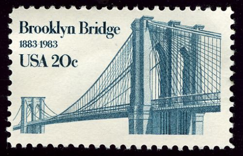 |
The Brooklyn Bridge Issued in 1983 In l869, actual construction of the Brooklyn Bridge, over the East River between Brooklyn and Manhattan, started. John Augustus Roebling, original architect of the project, was injured in an accident. Blood poisoning resulted in his untimely death. Fortunately his son, Colonel Washington Augustus Roebling, took over direction of the work involved from then on until completion. The grand opening was in May 1883. This great bridge handles two elevated railroad tracks, two streetcar (trolley) tracks, road lanes for vehicles, and even a foot walk for pedestrians. Just to observe the massive stone towers one is in awe of their height. They had to be lofty to carry the cables which in themselves-wire by wire-measured 16 inches in diameter. Tons of steel wire had to be used to hold up the incredibly heavy bridge deck. With the long main span, and two shorter spans, the bridge is 1 mile long. It is constructed of four cables, each anchored to plates of many tons, embedded in masonry foundations. Each foundation has a weight of 44 thousand tons. Every cable contains more than five thousand steel wires-a total of fourteen thousand miles of wire. It took thirteen years to build the bridge. At present thousands cross it each day. Even this writer, when working in New York, walked across this Bridge with friends and couldn't help but marvel at the magnificence of it all. |
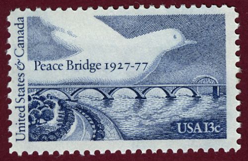 |
The Peace Bridge Issued in 1977 The Peace Bridge has been significant in the growth of the country. It crosses the Niagara River from Buffalo, New York to Fort Erie, Ontario, Canada. The stamp commemorates more than a century of friendship, trade, and peace between the United States and Canada. The two nations share the longest undefended border in the world. New advances in construction have been used. The Peace Bridge was built for pedestrian and vehicular traffic. Clearance at one end of the span is for canal or ship movement. The bridge is made up of five steel arches and a single truss span. At the elaborate opening ceremonies in 1927 a number of luminaries attended, including Edward, Prince of Wales. |
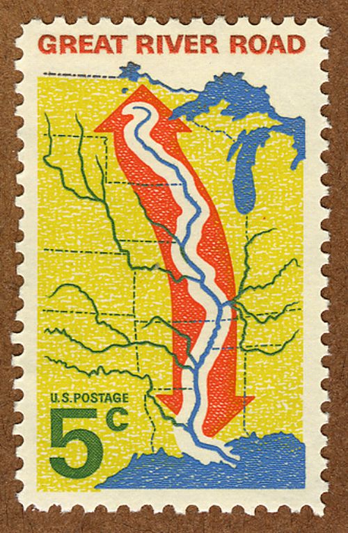 |
The Great River Road Issued in 1966 The beginning of the Great River Road goes back to 1936. The objective was to develop an extended highway corridor following the course of the Mississippi River. This proceeded for more than three thousand miles-from Ontario, Canada to the Gulf of Mexico at Baton Rouge, Louisiana. Ten states participated and were involved in the Mississippi River Parkway Commission: Arkansas, Illinois, Iowa, Kentucky, Louisiana, Minnesota, Mississippi, Missouri, Tennessee, and Wisconsin. In developing one of the most unusual scenic Byways in the country, each of the ten States formed their own parkway commission in carrying out the planning process. Existing highways are interconnected with sections of new construction. In 1940, the Commission met with the Bureau of Public Roads, forerunner of the Federal Highway Administration, and the National Park Service on developing parkway plans. A Bureau of Public Roads feasibility study was completed in 1951. These findings were presented to Congress in a joint report by the Secretary of Commerce and the Secretary of the Interior. The purpose was that it would benefit mainly the middle part of the country but have national significance as well. It is a viable tourist attraction with farm to market activity, retail trade, lodging, dining, and urban revitalization. Indeed the Great River Road is a national heritage corridor. |
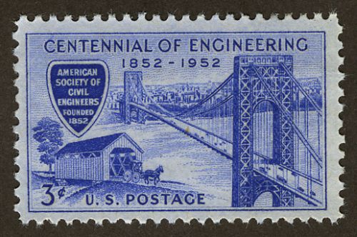 |
The George Washington Bridge Issued in 1952 The George Washington Bridge, over the Hudson River and dividing New York and New Jersey, is likely the heaviest and busiest of suspension bridges. Crossing the Hudson River at 178th Street, it is designed to carry huge loads. Twenty thousand tons of riveted steel for each tower was erected by massive derricks. Sixteen columns of steel 635 feet above water, as high as the Washington Monument, were put up. The steelwork was planned early as a skeleton, and was to be covered by concrete and granite. However, as the steel skeleton rose, story by story, the unexpected attractiveness of the exposed steelwork fascinated virtually everyone who witnessed it. Consequently, massive appeals arose to "forget the masonry" that had been planned for the towers. Each of the four cables holding up the deck is a yard in diameter and a mile long. The 100,000 miles of wire could encircle the globe four times. Construction began in 1927 and continued for the next 4 years. Provision was made for an additional (lower) deck, which has since been added. The bridge opened to traffic in 1931. Of course it honors the name of the great General who managed to form the thirteen original colonies into one United States. |
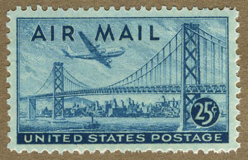 |
The San Francisco-Oakland Bay Bridge Issued in 1939 In 1928, a San Francisco delegation urged Congress to pass a bill authorizing a bridge to connect San Francisco with Oakland and Berkeley-with 5 miles of water between. The legislation was defeated, but in 1932 Congress approved a $73 million loan with the endorsement of President Herbert Hoover. The first shovel broke ground in 1933, and 3 years later the span was opened to vehicular traffic with excited celebration. After competing ferries cut their fares in half in 1927, the bridge traffic amounted to 23 thousand vehicles a day. With the opening of the Golden Gate Exposition in San Francisco in 1939, tolls were reduced from 50 to 40 cents, and when cut further to 25 cents, the ferries gave up. The roadway was built on two suspension bridges, with a central pier or anchorage at mid-channel. There are two decks: the top one handles six lanes for cars and light truck traffic. The lower deck carries three lanes for heavy trucks and multi-wheelers. There are also two streetcar (trolley) tracks provided. The structure is a combination of suspension and cantilever spans connected with a tunneled island. |
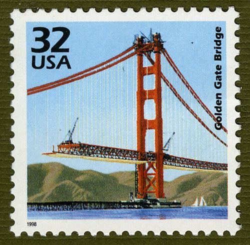 |
The Golden Gate Bridge Issued in 1998 The Golden Gate Bridge has the longest single span in the world, and the tallest bridge towers. Each of the cables has a diameter of one yard, and is composed of 27 thousand wires. Foundations have been sunk to solid rock 100 feet below water. The two main cables, each a yard wide, are outlined for the entire length by electric lights-magnificent evening sight. The Golden Gate Bridge and the Oakland-Bay Bridge were under construction at the same time; the Golden Gate Bridge is considered one of the most attractive spans in the world. The wonder of the extraordinary length of the span and the way it fits in with the site, make it one of the most exhilarating of bridges. |
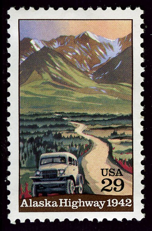 |
Alaska Highway Issued in 1942 There were years of consideration and talk concerning the strategic importance of defense and the Alaska Highway. Between the ending of the Great Depression and the beginning of WWII, actual work began on the Alaska Highway. This route continued north from the United States through mountain passes, connecting airports, and ending in Fairbanks. The War Department staff, feeling that Alaska must be protected, suggested the largest highway construction work known to date. During building, thousands of work troops, wearing clothes to withstand sub-zero temperatures hacked through woodlands using a variety of equipment including bulldozers. The road was primarily used for transporting equipment to airports. The Public Roads Administration established a district office in Seattle, Washington, along with field offices at other locations for contractors who had overseen work of thousands of road builders. In 1942, the Alaska Highway, through miles of scenic forest-land, was opened. This stamp was issued in l992, marking the 50th anniversary. |
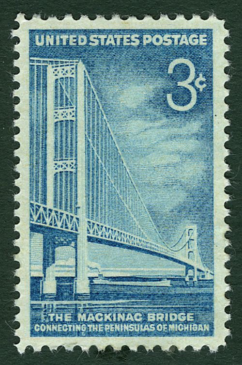 |
The Mackinac Bridge Connecting The Peninsulas of Michigan Issued in 1958 The Mackinac Straits Bridge extends over the Mackinaw Straits between Mackinaw City and St. Ignace, Michigan. The Mackinac Straits connects Lake Huron and Lake Michigan. The total suspension length of the span is more than a mile and a half between the cable anchors. The principle of the suspension bridge is that it has three essential parts: towers, anchorages, and cables. Towers for suspension bridges are built of stone or steel. Anchorages secure the ends of the cables, and most often are built of concrete or masonry. Cables are the most important element of a suspension bridge, since they carry the horrendous weight of the roadway. |
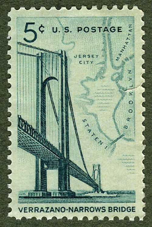 |
Verranzano-Narrows Bridge Issued in 1954 The Verrazano-Narrows Bridge, between Staten Island and Brooklyn, New York, is the longest single suspension bridge in the world. It is named for Giovanni da Verrazano, Florentine explorer who discovered New York harbor in about 1524. The massive span features a double deck thoroughfare, each wide enough for six lanes of traffic. The diameter of the cables measures 1 yard-identical with those on the George Washington Bridge. The Narrows Bridge is important in that it by-passes New York City. A map, illustrated on the stamp itself, pinpoints the positions of the Bridge with its close relationship to Staten Island and Brooklyn and also Manhattan and Jersey City, New Jersey. |