|
By accessing/using The Crittenden Automotive Library/CarsAndRacingStuff.com, you signify your agreement with the Terms of Use on our Legal Information page. Our Privacy Policy is also available there. |

PLAN AUTO DRIVE ALONG PALISADES
|
|---|
|
|
PLAN AUTO DRIVE ALONG PALISADES
The New York Times
April 5, 1914
Interstate Park Commission Has in Charge Work on New Scenic Highway.
WEST HUDSON ROUTE
Road Would Connect With Storm King Mountain Drive—Ferry at Dyckman Street.
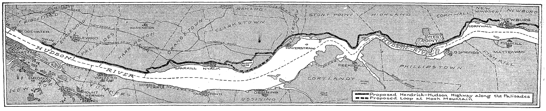
A new automobile highway, to be known as the Hendrick Hudson Drive, will throw open the beauties of the Palisades in all their scenic splendor to the motoring public. It will run along the face of the Palisades, when completed, from Fort Lee to the State line, and will there make connections with route 3 of the New York State highway system. The new river drive is to be completed in about a year, it is hoped, and it will be among the finest boulevards of its kind in the world. It will supply the missing link in good roads from New York to Albany on the New Jersey side of the Hudson, winding along the shore of the river at heights varying from almost the level of high water to about 400 feet. The drive will vary in width from 24 feet at its narrowest portion to about 70 feet. The widest stretch will be for a siding, as it were, to permit turning around, and will be situated where the expense will not be very great.
The Englewood approach to the drive, a fine piece of road work, which zig-zags to the top of the Palisades opposite Dyckman Street, will connect New York with Englewood and the northern part of New Jersey. The Palisade Interstate Park Commission, which has charge of the improvements now under way on the Palisades, announced recently that within a year an automobile ferry would ply between Dyckman Street and this approach, thus saving the round-about trip which now has to be negotiated before a New Yorker can reach the Palisades. The approach, an inclined road, runs first north for about half a mile, turns back, and runs south for about the same distance. The grade is sufficiently steep, however, to bring one to the top of the Palisades with the single turn. It has cost the commission about $200,000 to construct this one piece of road, as it was necessary to cut into almost perpendicular trap rock. This road is to have a sidewalk for pedestrians and will be in use this Autumn.
It is the intention of the committee, working in harmony with the State Highway Department, to improve the New Jersey side of the New York to Albany route. This route will be as short as the one now used on the New York side and will have beauties hitherto inaccessible. Above Newburg few changes are necessary, but at Hook Mountain, Storm King Mountain, and West Point a great deal of difficult construction work must be done.
Just above Nyack it is proposed to make the road fork, one branch running along the west shore of Rockland Lake and then to Walberg Landing. The other, or Hook Mountain, road will be cut through to the river and follow it closely until it reaches Walberg Landing, where the two roads reconverge, and continue to West Point. The carrying out of this plan depends largely on the appropriations and on the acquisition of the property along the river front of Hook Mountain.
At West Point negotiations with the Federal authorities to allow the road to run through the reservation are being carried on. There is every reason to believe that the commission will receive the desired consent, as the crowning feature of the plan, the road around the river side of Storm King, depends chiefly on this concession. Engineers are at work now surveying Storm King Mountain, and it is expected that the road will gradually reach a height of at least 400 feet at this point. It is but a short run from here to Newburg and from that point on up the river the route is now a good one.