


Managing Traffic Operations During Adverse Weather Events |
|---|
 Topics: Federal Highway Administration
|
Roemer M. Alfelor and C. Y. David Yang
Public Roads
January/February 2011 (Vol. 74 · No. 4)
FHWA is working with transportation and meteorological experts to develop strategies to reduce crashes and delays due to storms and harsh atmospheric conditions.
Weather affects the performance of the Nation's highway system every day. Rain, snow, ice, and the like are partly or fully responsible for more than 1.5 million highway crashes and more than 600,000 injuries and 7,000 fatalities on U.S. roads every year.
Further, motorists waste about 1 billion hours a year stuck in traffic related to adverse weather. In fact, weather is the second leading cause of nonrecurring highway congestion, accounting for about 25 percent of delays. Recent studies by the Federal Highway Administration (FHWA) estimate that adverse weather increases average travel times by 14 percent in the Washington, DC, area and 21 percent in Seattle, WA. During peak periods, travel time in Washington, DC, can increase by as much as 24 percent in the presence of rain or snow.
Despite the documented impacts of adverse weather on transportation, researchers do not fully understand the links between weather and traffic flow. However, through FHWA's Road Weather Management Program, partners from the transportation and meteorological communities are rising to the challenge. By studying, developing, and implementing weather responsive traffic management (WRTM) solutions, researchers are taking steps to improve traffic flow and operations during inclement weather, with the ultimate goal of minimizing delays and crashes.
Accurate and timely road and weather data are critical because they enable State and local departments of transportation (DOTs) to manage infrastructure in real time in response to existing and impending weather conditions and to warn motorists about changes in weather and road conditions. Advancements in intelligent transportation systems (ITS), road weather information systems, weather and traffic data collection, and forecasting technologies present new opportunities for better understanding how drivers behave in adverse weather and how their decisions affect traffic flow. Ultimately, these technologies can support WRTM strategies such as real-time modification of traffic signal and ramp meter timing, operation of automated deicing systems, and setting of variable speed limits.
FHWA recently conducted research to identify relevant datasets, including domestic and international sources, and analyzed the gaps between research needs and data availability. In addition, an effort is underway to develop applications using data culled from weather stations and the U.S. Department of Transportation's (USDOT) IntelliDriveSM initiative, which aims to enable safe, intero-perable, and networked wireless communications among vehicles, infrastructure, and passengers' personal communications devices.
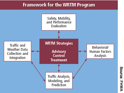 | FHWA's framework for weather responsive traffic management includes four core research areas that feed into three key strategies-advisory, control, and treatment-that DOTs can implement to improve the performance of highway systems in adverse weather. |
Weather Responsive Traffic Management
FHWA established the seeds of the Road Weather Management Program more than a decade ago to research, develop, and deploy strategies and tools to help road managers respond more effectively to inclement weather. In 2005, the Safe, Accountable, Flexible, Efficient Transportation Equity Act: A Legacy for Users directed FHWA and its partners to (1) maximize use of available road weather information and technologies; (2) expand road weather research and development efforts to enhance roadway safety, capacity, and efficiency while minimizing environmental impacts; and (3) promote technology transfer of effective scientific and technological advances.
The goal is to provide State DOTs with the knowledge and tools to address road weather in three key ways:
Advisory. Disseminate road weather information to the public through tools such as the 5-1-1 traveler information telephone services, variable message signs, and highway advisory radio.
Control. Regulate or optimize traffic flow in response to weather, such as through signal timing, ramp metering, and road closure.
Treatment. Clear roads of weather-related obstructions, as in snow removal and dust and fog control.
The end result is better decisionmaking by DOTs and motorists, resulting in improved reliability, safety, and mobility on the transportation system during adverse weather.
The FHWA Road Weather Management Program continues to review current practices, document the benefits of existing approaches, and identify needs, such as strategies applicable for use on arterials and freeways. Ongoing research will evaluate how weather and traffic information can improve traffic operations by enabling system managers to reset traffic signals and ramp meters; display advisory and warning messages; and make decisions on traffic control, maintenance, routing and diversion, and other operations.
Traffic Analysis And Modeling
Historically, road managers pulled weather and traffic data from static and fixed devices such as video cameras, traffic counters, loop detectors, airport weather stations, and environmental sensor stations. More recently, USDOT's IntelliDrive initiative has spawned a variety of approaches to capture traffic and weather information using moving vehicles. Making both static and dynamic information available requires active involvement by a range of participants in the transportation and weather communities.
Through the Road Weather Management Program, FHWA recently analyzed the effects of adverse weather on macroscopic (aggregate, big picture) traffic flow and quantified changes in traffic speed, capacity, and density. The researchers used data from traffic management centers (TMCs) in Baltimore, MD, Minneapolis-St. Paul, MN, Seattle, WA, and the National Weather Service stations at those cities' airports.
As reported in Empirical Studies on Traffic Flow in Inclement Weather (FHWA-HOP-07-073), published in 2006, the research revealed that precipitation (rain or snow) did not affect the density of the traffic stream, but it did affect traffic free-flow speed, speed-at-capacity, and capacity. Most of those parameters varied with precipitation intensity. Although capacity reductions of 12-20 percent occurred in snowy conditions, the reduction in capacity did not appear to be a function of the intensity of the snow (or rate of snowfall).
For the researchers, one of the more interesting findings was that the Twin Cities saw greater reductions (19 percent) in traffic stream free-flow speed and speed-at-capacity in snow than did Baltimore (5 percent). Those relative figures might seem counterintuitive considering the Twin Cities have higher annual snow totals than Baltimore. A possible explanation is that drivers who are more accustomed to snow are more aware of its dangers -- and slow down. This theory also might explain the higher reductions observed in a Canadian study, as reported in the 1994 article "Effect of Adverse Weather Conditions on Speed-Flow-Occupancy Relationships" in the Transportation Research Record.
A 2009 followup study, Microscopic Analysis of Traffic Flow in Inclement Weather (FHWA-JPO-09-066), analyzed the impacts of adverse weather on microscopic traffic behavior. Microscopic analysis describes individual driver responses to weather conditions, such as changing lanes, merging onto a freeway, making a left turn across traffic at an intersection, or adjusting the distance behind a lead vehicle. Studies that videotaped individual vehicle movements at intersections or freeway merge locations provided a rich source of data for analysis.
The video-recorded data helped provide a better understanding of how drivers respond to adverse weather, focusing on three types of driving behaviors -- car following, gap acceptance, and lane changing. The video data also helped the FHWA researchers incorporate microscopic models into existing microsimulation tools to help model and evaluate WRTM strategies.
In one of the studies, the FHWA researchers used video data collected at several intersections near Blacksburg, VA, to determine whether drivers alter their gap acceptance behavior in rainy weather. The findings indicate a more cautious approach to left-turn gap acceptance in the rain (such as higher critical gaps), which could influence the effectiveness of intersection signal timing plans.
FHWA also conducted research on car-following behavior using a dataset that consists of observations of individual drivers as they navigate an icy test track in Japan. The goal of the research is to analyze how the vehicle speeds and distances between vehicles are affected by the icy road conditions. Research also is underway to collect and analyze detailed information on gap acceptance behavior at intersections in snowy conditions.
"The impact of weather on traffic flow isn't simple and straightforward," says Dave Kinnecom, a traffic management engineer with the Utah Department of Transportation (UDOT). "The effect on traffic can depend on the timing of the storm, when and how the roads are treated, and the temperature of the pavement. Sometimes, what seems to be a minor snowstorm can have a significant impact on traffic when there are a lot of minor incidents. At other times, moderate snow has had virtually no effect."
Traffic Estimation And Prediction
Another area for expanding use of weather data is in traffic estimation and prediction. Researchers with FHWA's Road Weather Management Program recently incorporated weather factors into existing Traffic Estimation and Prediction Systems (TrEPS). Using TrEPS, researchers can predict where and when drivers will travel on a road network and apply dynamic control and traffic management strategies proactively rather than reactively.
FHWA modified two TrEPS prototypes -- DYNASMART-P, a system for transportation planning, and DYNASMART-X, a real-time system for predicting traffic conditions and patterns -- to account for weather impacts, improving their traffic estimation and prediction capabilities and overall utility. A 2009 FHWA study, Incorporating Weather Impacts in Traffic Estimation and Prediction Systems (FHWA-JPO-09-065), addressed supply and demand aspects of traffic response to adverse weather, including driver response to various weather-specific interventions, such as advisory information (variable message signs) and control actions (variable speed limits).
For this study, researchers with the Road Weather Management Program implemented the weather-related features in DYNASMART and applied the system to a real-world road network. Using DYNASMART, the researchers identified and modeled the supply-side and demand-side elements of TrEPS to account for changing weather conditions and the availability of traveler information systems and WRTM devices. The study provides a direction for future development toward a proactive approach to traffic management under adverse weather that incorporates weather effects in transportation network analysis tools. Consequently, TMCs will be able to implement more effective strategies during severe weather conditions to improve travel safety and mobility.
Further, FHWA is working to translate these advances in traffic estimation and prediction into practice. Specifically, the FHWA researchers are calibrating the model for a variety of local conditions and traffic patterns for implementation and evaluation in the context of regional planning and operations. Also, the researchers are focusing on weather-related traffic management and control measures, and are studying how to interface their deployment and evaluation with the TrEPS decision-support tools.
According to Jack Stickel, manager of transportation data services with the Alaska Department of Transportation & Public Facilities, degradation of road surface conditions is highly correlated to expanded segment travel time. "Measuring the changes in traffic speed and thus segment travel time can go a long way in estimating the impacts of precipitation, sudden warming that melts snow and ice on the road surface, or increasing winds that require additional driving safeguards," Stickel says. "Segment travel time can be used as a proxy for changes in the road weather environment."
Traffic and Weather Data Collection and Integration
A TMC usually serves as the hub of a regional transportation system and communicates traffic information to motorists and the public. Integrating weather information and decision-support functions in TMC operations supports a transportation agency's ability to manage traffic, dispatch maintenance forces, and respond to weather-related problems and other emergencies.
To support TMCs and their activities, FHWA is working to define a framework for the types of weather and traffic data needed and how to integrate them to support effective operational strategies. The Road Weather Management Program is looking at the types and characteristics of data, the sources and procedures used to gather them, and how transportation agencies and motorists use this information in making decisions. For example, some motorist decisions affected by weather and traffic conditions include whether to make the trip, when to make the trip, what routes to take, and what modes of travel to use. Timely, accurate, and relevant weather and traffic information requires effective methods for data collection, integration, and dissemination.
In 2008, FHWA published Integration of Weather Information in Transportation Management Center Operations: Self-Evaluation and Planning Guide (FHWA-JPO-08-057) to help TMCs identify their weather information needs and develop plans to better integrate the information in their daily operations. The guide stemmed from recommendations in a 2006 FHWA study, Integration of Emergency and Weather Elements Into Transportation Management Centers (FHWA-HOP-06-090).
This self-evaluation guide is designed to help a TMC integrate weather information and technologies into its daily operations. The first step is to identify the relevant weather events in a TMC's jurisdiction, their impacts on traffic operations and infrastructure, and processes for responding to those events. From there, the guide walks road managers through the process of prioritizing identified needs for the application and integration of weather information, and identifying strategies and solutions best suited to meeting the TMC's needs. In addition, the guide summarizes how to develop a plan for integrating weather information and includes a list of strategies to help TMCs fill information gaps.
Since the guide's publication, TMCs in Cheyenne, WY, Colorado Springs, CO, Kansas City, MO, Milwaukee, WI, Sacramento, CA, and four more in Louisiana have conducted their own self-evaluations. Most of them have developed plans for integrating weather information. The Sacramento TMC developed a weather alert system that automatically generates adverse weather warnings and alerts to help TMC operators post appropriate messages and advisory information for travelers.
"The FHWA weather integration self-evaluation process has had numerous benefits for the Wyoming Department of Transportation [WYDOT]," says Vince Garcia, GIS/ITS program manager at WYDOT. "The guide was very simple to use and it focused our attention on best practices. Such focus enabled us to concentrate our efforts and lend credence to our ITS requests when pursuing funding opportunities with WYDOT's executive staff."
Human Factors and Road Weather Information
To be effective, the content, format, and timing of weather information needs to be consistent with what travelers need, want, and will use. Toward that end, in March 2010, FHWA published the Human Factors Analysis of Road Weather Advisory and Control Information: Final Report (FHWA-JPO-10-053). The goals of the study were to evaluate the current state of the practice in communicating weather-related traffic advisory and control information, and to recommend ways to improve those practices. The research derived a preliminary set of guidelines for communicating and presenting road weather information that meet the needs of drivers and travelers under various weather conditions and travel scenarios.
The guidelines are contained in a decision/design document that enables traffic managers to work through a series of questions to identify appropriate road weather messages and dissemination methods based on the type of weather event, anticipated mobility impacts, and the types of traveler decisions that could be made. For example, a transportation agency can use the design guide to identify the specific content, format, and delivery mechanisms for warnings and advisory messages to travelers who will be driving on a highway corridor that is experiencing adverse weather such as heavy snow, rain, or fog.
"Utah has focused on improved traveler information," says UDOT's Kinnecom. "We want to inform the traveler of not just the weather but current and projected road conditions. We have put a 'Road Weather' page on our 'Commuterlink' Web site that features forecasted road conditions out to 18 hours. We have an emergency alert feature on the Web site that advises users of road closures, chain or four-wheel drive restrictions, and expected driving conditions. UDOT also uses 5-1-1 to advise travelers of both forecasted weather and road conditions."
The TMC in Colorado Springs, CO, uses both TwitterTM and dynamic message signs [DMSs] to provide information on forecasts of adverse weather, including snow, heavy rain, and fog. "Most of the information at present tends to be regional, although the conditions from neighborhood to neighborhood can vary greatly during adverse conditions," says Robert Helt, principal traffic engineer with the city of Colorado Springs. "With the addition of small DMSs at various signal locations, the conditions reported become more relevant to each neighborhood."
Future Studies
Although these and other activities across the industry have significantly advanced the state of the practice in weather responsive traffic management, a few gaps still remain. Recent advances in mobile sensing and data collection technologies for traffic and weather, including those coming from the IntelliDrive program, can help researchers and practitioners use available data to improve forecasting and decisionmaking, including traffic management. For example, IntelliDrive's Dynamic Mobility Applications capitalize on vehicle-infrastructure connectivity by using data from vehicle probes and other real-time data sources, and enable TMCs to manage mobility between and across modes more effectively while providing information to travelers to support dynamic decisionmaking.
In the near term, FHWA will expand development and deployment of decision-support modules for traffic management similar to its Maintenance Decision Support System (MDSS), which is a decision-support tool for winter road maintenance. MDSS provides maintenance managers with precise forecasts of surface conditions and recommendations for treatments for specific routes. Using MDSS as a model, FHWA developed a concept of operations and established rules of practice for traffic management, some of which are being implemented as part of regional demonstrations associated with Clarus (Latin for "clear"), an FHWA research and development initiative to demonstrate and evaluate the value of road weather information to transportation users and operators.
"We cannot change the weather," says Paul Pisano, team leader of the FHWA Road Weather Management Program, "but we can reduce its impacts on highway operations and safety by using weather forecasts, identifying threats to travelers and the highway system, and responding proactively rather than reactively."
Roemer M. Alfelor has more than 20 years of experience in transportation and currently manages the WRTM research for the FHWA Road Weather Management Program. He serves as secretary of the Transportation Research Board's (TRB) Committee on Surface Transportation Weather. He holds a master's degree in transportation from the Massachusetts Institute of Technology and a Ph.D. in civil engineering from Carnegie Mellon University.
C. Y. David Yang is a research engineer with FHWA's Office of Operations Research and Development. He is responsible for traffic modeling and simulation research at the Turner-Fairbank Highway Research Center. He is chairman of TRB's User Information Systems Committee and serves on the editorial board of the Journal of Intelligent Transportation Systems: Technology, Planning, and Operations. He received his bachelor's, master's, and doctoral degrees in civil engineering from Purdue University.
For more information, contact Roemer Alfelor at 202-366-9242 or roemer.alfelor@dot.gov, or David Yang at 202-493-3284 or david.yang@dot.gov.
Article reprinted from the Federal Highway Administration's January/February 2011 issue of Public Roads.